Recent advances on coastal remote sensing and applications to Castelldefels and Barcelona beaches
Feb 04, 2021
Daniel Calvete and Francesca Ribas, from the group of Nonlinear fluid dynamics, have been working for a few years on the development of image analysis techniques to extract information from video cameras installed on the beaches of Castelldefels and Barcelona, to be able to quantify their evolution
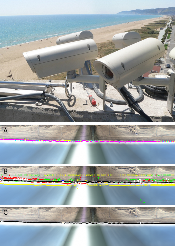
Monitoring the evolution of beaches at high spatio-temporal resolution is crucial to manage them, especially in the present framework of climate change. Researchers from the Nonlinear fluid dynamics (DF) research group in the Physics department have published three articles in the last six months with new results in the journal Remote Sensing, where they address two important open problems in coastal video-monitoring. They apply the developed algorithms to the images obtained from the cameras in Castelldefels (see photo that accompanies the text) and Barcelona, but they could be directly used in the thousands of video-monitoring stations around the world. These works have been done in collaboration with researchers from the Institut de Ciències del Mar (ICM, CSIC, Barcelona).
The first problem is that of automatic image calibration. In order to extract quantitative information from video cameras, the position of each pixel of the image must be first transfered to the real world. Once the position of some control points in the study area have been measured with a differential GPS, it is necessary to locate them in the image and apply a linear relationship. The process of finding the points in the image is usually done by hand and is time-consuming. In the articles, progress is made on a methodology to do the calibration automatically. This will allow, in the future, to correct the hourly changes in the images due to the movement of the tower where they are installed and the expansion of the lenses, thus reducing detection errors.
Camera Calibration for Coastal Monitoring Using Available Snapshot Images Gonzalo Simarro, Daniel Calvete, Paola Souto and Jorge Guillén Remote Sens. 2020, 12(11), 1840;
The Influence of Camera Calibration on Nearshore Bathymetry Estimation from UAV Videos Gonzalo Simarro, Daniel Calvete, Theocharis A. Plomaritis, Francesc Moreno-Noguer, Ifigeneia Giannoukakou-Leontsini, Juan Montes and Ruth Durán, Remote Sens. 2021, 13(1), 150;
The second adressed open problem that is that of the automatic shoreline detection from the images. Properly registering the shoreline time evolution is crucial for coastal management and there is not yet an algorithm to extract them from existing video images that is fully satisfactory. In the article a methodology is presented that combines the results of different shoreline detection algorithms in order to obtain an accurate result when compared to the manually digitized shorelines. In the figure that accompanies the text there are examples of (A) manual shorelines digitized by three expert users (in different colors), (B) raw shorelines out of the four methods (red, green, blue and yellow) and combined shoreline (white and black) and (C) filtered shoreline (white and black) of Castelldefels beach on 27 November 2017 at 12 h. The shorelines are detected from the time exposure planview image below them, which are obtained from 10 min of video-camera oblique images after aplying the calibration procedure. When the new algorithm is applied to the beaches of Barcelona region, the final computed shorelines have RMSE of the order of 2 m or smaller.
Automatic Shoreline Detection from Video Images by Combining Information from Different Methods Francesca Ribas, Gonzalo Simarro, Jaime Arriaga and Pau Luque Remote Sens. 2020, 12(22), 3717;

Share: