Qi Liu defends his thesis on GNSS-based Global Ionospheric Maps: real-time combination, time resolution and applications on space weather monitoring
Apr 20, 2022
Qi Liu telematically defended his thesis supervised by Professor Manuel Hernández-Pajares on April 14, 2022, entitled "GNSS-based Global Ionospheric Maps: real-time combination, time resolution and applications on space weather monitoring”. The thesis focuses on GIMs including the combination of Global Ionospheric Maps (GIMs) from different centers in real-time, evaluation of real-time GIMs, investigation of the impact of temporal resolution on GIMs, and applications of GIMs on new indices about spatial-temporal components of the VTEC gradient as well as ionospheric storm-scale.
The research of this paper-based dissertation is focused on the Global Ionospheric Maps (GIMs) based on Global Navigation Satellite System (GNSS) including real-time combination, validation, time resolution and applications. The novelty of these works can be summarized as follows:
The first contribution is to connect GIM assessment methods in post-processing and real-time mode including Jason-altimeter Vertical Total Electron Content (VTEC) assessment, GNSS differences of Slant Total Electron Content (dSTEC) assessment and real-time dSTEC (RT-dSTEC) assessment. With the RT-dSTEC assessment, we can assess the accuracy and calculate the weight of different real-time GIMs for combination in real-time mode. The Jason-altimeter VTEC assessment and dSTEC assessment can be used for evaluating GIMs over oceans and continental regions, respectively. In addition, the accurate GIMs shown in the GIM assessment methods can be regarded as reliable representations of global VTEC.
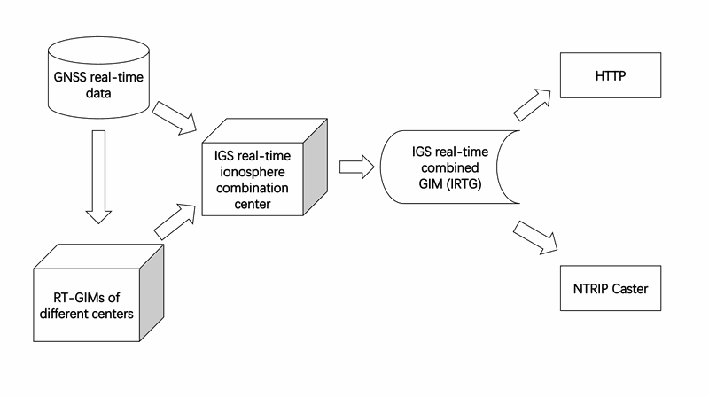
The second contribution is to apply the RT-dSTEC assessment in real-time mode for the combination of different International GNSS Service (IGS) real-time GIMs. The IGS combined real-time GIM is generated to provide robust ionospheric corrections for real-time GNSS positioning and reliable global VTEC distribution for earth observations. The current status of IGS real-time GIMs from different centers is summarized and compared. The Jason-altimeter VTEC assessment and dSTEC assessment in post-processing mode are used for the validation of IGS real-time GIMs. The sensibility of real-time weighting technique by RT-dSTEC assessment is also verified.
The third contribution is to investigate the influence of temporal resolution on the performance of GIMs. The variation of ionosphere is typically assumed as linear between two consecutive GIM TEC maps in a sun-fixed reference frame for up to few hours. However, the variation of ionospheric TEC is irregular due to the occurrence of space weather events. One and a half solar cycle of the IGS GIM with higher time resolution and accuracy (the UPC-IonSAT Quarter-of-an-hour time resolution Rapid GIM, UQRG) has been taken as a baseline to downsample them to all possible sub-daily temporal resolutions. The performance of the resulting GIMs has been evaluated taking into account the geographical position, solar and geomagnetic activity by Jason-altimeter VTEC assessment and dSTEC assessment.
The fourth contribution is to propose a new way of estimating the spatial and temporal components of the VTEC gradient. The determination of ionospheric perturbation degrees can be helpful for guaranteeing the safety level of Satellite-Based Augmentation System (SBAS) and Ground-Based Augmentation System (GBAS) services. In order to estimate the spatial and temporal components of the VTEC gradient on a global scale, the accurate UQRG is selected. The VTEC gradient indices derived from UQRG GIMs (VgUG) allow users to obtain full (non-relative) values of TEC spatial gradients and temporal variations separately. The Regional VTEC spatial Gradient indices, based on UQRG (RVGU) and the Regional Ionospheric Disturbance index based on UQRG (RIDU), are proposed to estimate the regional ionospheric perturbation degree over selected regions. In addition, the spatial and temporal components of VTEC gradient at grid points of UQRG on a global scale are also introduced.
The fifth contribution is to define a new ionospheric storm scale. The ionospheric response to high geomagnetic activity, ionospheric storm, can enlarge GNSS positioning errors by the increase of ionospheric electron density and disable high-frequency communications by the decrease of ionospheric electron density. To characterize the ionospheric state on a global scale, reliable global VTEC distribution is essential. According to previous studies, UQRG is one of the most accurate GIM. In this regard, the new Ionospheric storm Scale based on UQRG, IsUG, is proposed.

Share: