Mowen Li defense his thesis on Ground and Marine Resilient Integration Technology of Multi-Source Sensors for Navigation and Positioning
Aug 05, 2024
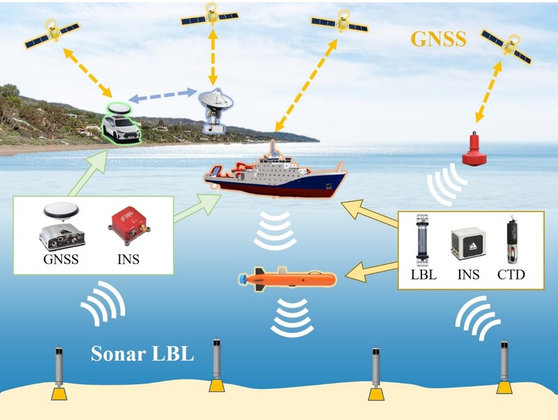
Mowen Li defended his thesis co-supervised by Dr. Adria Rovira Garcia and Prof. Dr. Tianhe Xu on July 31st 2024 at Shandong University, Weihai, China. Entitled "Ground and Marine Resilient Integration Technology of Multi-Source Sensors for Navigation and Positioning", the thesis presents the resilient integration technology of GNSS/INS/LBL/CTD for the ground, marine and seamless Navigation and Positioning
Integration of multi-source sensor is the main development direction of modern technology for the high-accuracy, high-reliability and high-stability Positioning, Navigation and Timing (PNT) service in multiple scenes. Global Navigation Satellite System (GNSS) can provide users with a unified spatio-temporal datum and full-time, accurate global navigation and positioning service, but it is easy to be obstructed and interfered by the surroundings or equipment. Thanks to the good independence and anti-interference ability, Inertial Navigation System (INS) has the ability to navigate without external information, but it requires external information to calibrate and suppress the error accumulation. Long Baseline sonar (LBL) system provides navigation and positioning service for underwater users, but its positioning accuracy and stability is limited by the sound velocity and observation geometry in the ocean. The Conductivity/Temperature/Depth profile (CTD) provides additional vertical measurement and salinity information for positioning and scene recognition. The resilient integration of the above-mentioned sensors can address the limitations and disadvantages of single sensor, and achieve the more continuous, stable and reliable navigation and positioning service for the user.
Based on the integrated observations of GNSS, INS, LBL and CTD, this thesis proposes a recognition algorithm for the overwater and underwater scene. The proposed algorithm achieves scene recognition through analyzing the GNSS observable satellite number and DOP, the depth and salinity measured by the CTD, and LBL observable signal number. The proposed algorithm achieves fast recognition in the practical experiment.
Combining all the achievements mentioned above, the overwater and underwater seamless navigation and positioning based on resilient integration of GNSS/INS/LBL/CTD is achieved. The experimental results show that the proposed resilient integration technology improves the positioning performance in all the scenes from overwater to underwater. One multi-source sensor resilient integrated navigation and positioning software has been developed with C++ programming language, on the basis of above-mentioned studies and researches.

Share: